The following is an email exchange between myself and Mr. Munger, the Brazos County Engineer. The question is “What can be done to selectively improve the quality of a few roads in Brazos County for cyclists?” Mr Munger asked that I collect feedback from the cycling community and present it to him and the Brazos County Metropolitan Planning Organizations (MPO) – of which I sit as an unofficial community advisor. There is a feedback form at the bottom of the email exchange. Please DO NOT CONTACT MR MUNGER – he asked that I collect feedback and present it at one time.
For clarity I posted my question and then Mr. Munger’s answer and did a bit of formatting.
Hi Alan,
[snip] Bottom line here is an idea to deconflict some rural cycling/vehicle contention and show the county as being bike friendly (which helps companies like ViaSat build 85,000 sq ft technology centers in the County).
From a driver’s point of view, cyclists are an annoyance on the country roads especially if there are curves or hills. They tend to take up too much of the road and cause me to slow down
From a cyclist’s point of view the county roads are frequently in “poor” condition (given the size of a cyclists tires and pressures) or are “upgraded” with the rough coat which reduces cycling traction (as there is always gravel that is breaking loose) and is rough to ride on. Coupled with a lack of shoulders – cyclists have to ride in the road and are often dodging debris and gravel patches only they can see.
I propose setting up a few designated cycling routes in the county.
The thinking is that drivers now are put on notice that the designated/marked/striped roads are now likely to have cyclists – who have a safe place to ride. The cyclists don’t have as rough a road, a designated area, and therefore understand they have to follow the rules. Let the Sheriff/Constables patrol to encourage the cooperative behavior. The result is that cyclists prefer to ride where they are welcome, thus reducing cycling traffic on other roads.
To achieve this I believe that when roads are updated you do not put the gravel on the shoulder and stripe it. Add some signage and work with the local cycling groups (who have multiple social media sites) and the broadcast/print media to promote the new “feature”.
I do realize the cost of aggregate is small, but over many miles it may (?) pay for signage and maybe some of the paint… Plus, I suspect there are grants.. like asking for some funds from some of the $13 million/year that our local transportation systems just won (i.e. the MPO).
So the question would be where? I propose two areas that are well known to local cyclists as potential prototypes for study. One is the “Rotary Route” which is Old Reliance Road out to FM 2038 and down the “Weedon” complex of roads back to Hwy 30. The other is the “Banker’s Route” which is Rock Prarie to Peach Creek under Hwy 6 on Hwy 159, on to Milican, on to “Allen Farm” and as far out to Hwy 105 as possible.
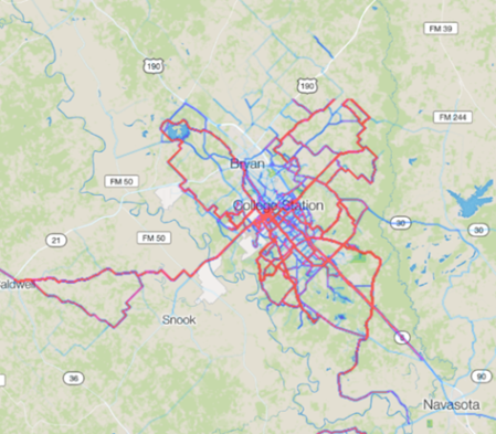
Early 2017 Strava heat map for Brazos County
My supporting evidence of use is this is a heat map from Strava (a Facebook for cyclists and runners). The more red a line is – the more traveled (i.e. hot). The data is drawn from GPS phones, cycling computers and watches.
I realize this is eventually an MPO/ATAP endeavor, but the most dangerous roads are the County’s and the gravel overlay is a contributing factor. Thus I’m asking you to help me get the facts straight.
Thank you
Don R. Gilman, PE, PMP
*** Mr Munger’s Reply ***
Mr. Gilman:
Thanks for your detailed emails. I believe that I understand your desires. I have heard many of those same desires from other county employees who are also avid cyclists. As much as “everyone wins” is a desired goal, perceived wins to achieve the limited routes you described for bicyclists are going to be incremental. That would be much easier to achieve if trucks could be banned from such a route, but state law does not provide counties much leverage in the ability to provide such a ban on a public road.
The linked bicyclist blog provides a pretty good understanding of the use of seal coats: http://kentsbike.blogspot.com/2011/07/road-surfaces-chip-seal-rolling.html
Personally, I would love to maintain 480 miles of hot mix surfaced roadways. In addition to being a smoother ride, it would be the easiest to maintain and operate. The State of North Carolina has a great secondary road system. The State maintains the secondary roads, not the counties. The State of North Carolina also has an income tax and a higher motor fuels tax than the State of Texas. There’s a difference in public policy which supports the superior road network when comparing the two states and contrasting the roadways.
Historically, Brazos County roadways have “evolved”. Our silty and clayey soils provide weak subgrades. Earlier in the 20th century, the subgrades were strengthened with river gravel and base courses of iron ore or limestone aggregate were added to strengthen the roadbed. The county was largely agricultural and in the latter part of the 20th century, there was a great deal of effort by the Commissioners Court to treat the surface of the roadway to control dust and provide a more reliable surface for the increasing population than gravel roads generally provide. The surfaced roadways were not engineering efforts, but the pavements held up fine to cars and pickups of farmers/ranchers.
With urbanization (100’s of dump trucks and concrete mixers for each new home), substantial construction efforts on A&M campus and the fracking revolution in oil exploration – we have seen the number of trucks increase greatly on our county road network. Deterioration to the “evolved” county roads quickly follows increased truck traffic (see photo below of roadway which has since been reconstructed).

Oil truck on Brazos County roads with patched shoulder
Today Brazos County maintains about 480 miles of roadway composed of:
- Concrete – 1.47 miles (largely a jointed concrete roadway from Old SH 6 which the county now maintains in far south Brazos County)
- Hot Mix – 79.35 miles (some of which now has seal coat surface as a pavement preservation tool)
- Gravel Base (untreated surface) – 99.21 miles
- Seal Coat (Surface Treatment) – 299.16 miles
The lowest cost roadways to maintain are generally the gravel roads. They are generally gravel because they have low traffic demands (daily counts less than 200 with many often less than that). We can blade and provide a smooth surface with one motorgrader operator periodically and base materials costing $25/ton. Many of our remaining gravel roads are roads which are in cotton fields (off FM 50), or roads which are submerged in floods as they are near the Brazos or Navasota River, or roads with very poor subgrades (along and south of OSR). Residents living along gravel roads (Forsthoff, Whiteswitch, Millican area, etc.) demand surfacing currently to minimize their ongoing issues with dust.
Seal Coat (or chip seal) roadways carry more traffic (daily counts between 200-1500) but most of our seal coat mileage are on roadways which are not “engineered” but they are a continuance of the evolution described earlier. We can generally maintain these roadways with a maintenance seal coat surface treatment every 5-6 years (costing approximately $2.00/Square Yard), periodic crack seal and pothole repair as needed with asphaltic materials costing $85/ton and requiring a full crew for traffic control, excavating damaged roadway materials, installing and compacting repair materials.
Hot Mix roadways are a dense, compacted surface which are much more resistant to frequent stopping and turning movements (at driveways or intersecting roadways). This department places hot mix as our budget allows on pavement roadbeds which have been engineered to carry 80,000 pound vehicle loads for many years. Hot Mix costs about $7.00/ Square Yard and due to our extreme climate (rainfall, strong UV) oxidation of the hot mix asphalt occurs and requires some sort of maintenance in 7-8 years (either seal coat or mill/overlay).
We don’t believe it is prudent to spend tax dollars on the more expensive surface if we don’t have confidence in the underlying sub-base and base to withstand dump trucks, oil field trucks which can literally utilize any county roadway in abundance at any time (oil exploration currently occurring along Weedon Loop, Bird Pond, Tonkaway that I am aware of with additional requests coming to this office increasingly). It would be akin to repainting a house that has structural problems.
When we do have confidence in the underlying pavement structure and we have the traffic demands as justification, then we work to place a hot mix surface (as we have done on portions of Merka, Shirley Road, Macey Road, Elmo Weedon, portions of Steep Hollow, Marino Road, Dilly Shaw Tap, IGN, Greens Prairie Trail, Rock Prairie West, Jones Road in the past 5 years).
Roads which we are currently working to improve to an engineered standard are Cherokee, Mesa Verde, remaining portion of Dilly Shaw Tap, Smetana and Walnut. Arrington Road, Straub/Stousland, Forsthoff Lane are in ROW acquisition to widen and improve.
Your suggestion for the bike network on the “hot” routes would require a policy change that this department could follow if directed accordingly by our elected body (the Commissioner’s Court). In my experience, state and federal funding for bicycle/pedestrian facilities (multi-modal, alternative transportation) can be justified in denser populated urban areas as a means to mitigate automobile congestion and improve air quality. With our student population in Bryan/College Station, it also fulfills an economic need for those students unable to afford a car for transportation. When the bicycle facility is located in a more rural area, that same justification does not hold water and the facility is seen more as a recreation facility and funding would be going toward something which may not necessarily be the basic type of need which local government tries to fulfill. Brazos County does not maintain any parkland either at this time.
I know there are 2 sides to every story. I understand your desire and I hope this correspondence better helps you to understand the limitations of this department in directly addressing your request. We believe that we would need to fully reconstruct the sub-grade, base in order to provide hot mix surface to accommodate the proposed bicycle network while also accommodating the heavier and more destructive truck network which shares some of the routes you described. This would pull resources from ongoing roadway planning/construction efforts to provide surfacing to currently unsurfaced roads or to reconstruct pavement structures which are at the end of their pavement life and require replacement.
Changing the discussion from roads to the equipment – I know that bicycles are expensive “instruments”, but what are your thoughts toward utilizing “gravel bikes” on our county roads such as: https://gearpatrol.com/2014/06/05/best-gravel-bikes/ ? What is your experience in how “gravel” bikes compare to road bikes on the “typical” chip seal county road?
Best regards,
R. Alan Munger, PE
County Engineer
Brazos County Road & Bridge
2617 Highway 21 West
Bryan, TX 77803
Mr Munger has asked that I collect feedback and then forward to him and the Brazos County Metropolitan Planning Organizations (MPO) which coordinates Bryan, College Station, TAMU, the County and TXDOT’s efforts in the area. Please DO NOT contact him directly at this time.
What do you think?


 Posted by TX Aggie SWE